
NOAA’s GOES-16 satellite, formerly known as GOES-R, has sent its first, high resolution images, and now people around the world can see what this revolutionary satellite sees. These images from GOES-16’s new Advanced Baseline Imager (ABI) instrument show the complete full disk of the Western Hemisphere and the continental United States in all 16 channels of the ABI instrument.
GOES-16 was launched on Nov. 19, 2016 at 6:42pm EST from Cape Canaveral, Florida. The first images usher in a new era of Earth and space weather observation for the U.S.
“Seeing these first images from GOES-16 is a foundational moment for the team of scientists and engineers who worked to bring the satellite to launch and are now poised to explore new weather forecasting possibilities with this data and imagery,” said Stephen Volz, Ph.D., NOAA’s Assistant Administrator for Satellite and Information Services. “The incredibly sharp images are everything we hoped for based on our tests before launch. We look forward to exploiting these new images, along with our partners in the meteorology community, to make the most of this fantastic new satellite.”
GOES-16 is the first spacecraft in the GOES-R series of four new NOAA geostationary satellites, capturing higher resolution images of weather patterns and atmospheric phenomena than any of NOAA’s GOES satellites to-date. The higher resolution will allow forecasters to pinpoint the location of severe weather with greater accuracy, ultimately saving lives.
 This composite color full-disk visible image was captured at 1:07pmEST on January 15, 2017, and created using several of the 16 spectral channels available on the ABI. The image shows North and South America and the surrounding oceans. GOES-16 observes Earth from an equatorial view approximately 22,300 miles high, creating full disk images like these from the coast of West Africa, to Guam, and everything in between.
GOES-16’s ABI instrument, built by Harris Corporation, can multi-task in a way that older satellites cannot. It can provide a full disk image of the Earth every 15 minutes, one of the continental U.S. every five minutes, and has the ability to target regional areas where severe weather, hurricanes, wildfires, volcanic eruptions or other high-impact environmental phenomena are occurring as often as every 30 seconds. ABI covers the Earth five-times faster than the current generation GOES imagers, and has four-times greater spatial resolution, allowing meteorologists to see smaller features.
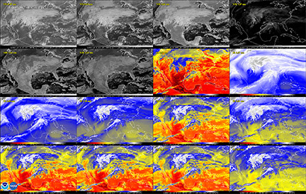
This 16-panel image shows the continental United States in the two visible, four near-infrared and 10 infrared channels on ABI. These channels help forecasters distinguish between differences in the atmosphere like clouds, water vapor, smoke, ice and volcanic ash.
GOES-16 has three-times more spectral channels than earlier generations of GOES satellites. The significant storm system that crossed North America on January 15, 2017 and caused freezing and ice that resulted in dangerous conditions across the United States is clearly visible.
“This image is much more than a pretty picture, it is the future of weather observations and forecasting,” said Louis W. Uccellini, Ph.D., director, NOAA’s National Weather Service. “High resolution imagery from GOES-16 will provide sharper and more detailed views of hazardous weather systems and reveal features that previous instruments might have missed, and the rapid-refresh of these images will allow us to monitor and predict the evolution of these systems more accurately.
As a result, forecasters can issue more accurate, timely, and reliable watches and warnings, and provide better information to emergency managers and other decision makers.”
Once operational later this year, GOES-16 will support short-term forecasts, watches and warnings, maritime forecasts, wildfire monitoring, volcanic ash monitoring and space weather predictions. The National Weather Service and other forecasters using GOES-16 imagery will now have a wide range of uses and societal benefits in areas such as severe weather, energy, transportation and commerce. GOES-R will improve hurricane tracking and intensity forecasts, increase thunderstorm and tornado warning lead time, improve aviation flight route planning, provide data for long-term climate variability studies, improve solar flare warnings for communications and navigation disruptions, and will enhance space weather monitoring.
In May, NOAA will announce the planned location for GOES-16. By November 2017, GOES-16 will be operational as either the GOES-East or GOES-West satellite. Following on the heels of GOES-R will be GOES-S, the next spacecraft in the series, which is planned for launch in Spring 2018. GOES-S is undergoing environmental testing at Lockheed Martin Corporation’s Littleton, Colorado, facility, where it was built. A full set of environmental, mechanical and electromagnetic testing will take about one year to complete. After its initial on-orbit checkout the GOES-S satellite will be moved into the other operational position as GOES-17.
NOAA’s satellites are the backbone of its life-saving weather forecasts. GOES-16 will build upon and extend the more than 40-year legacy of satellite observations from NOAA that the American public has come to rely upon.
For more information about NOAA’s satellites visit: http://www.nesdis.noaa.gov/ .
GOES-16 Image Gallery: https://www.nesdis.noaa.gov/content/goes-16-image-gallery