
The State of California released its draft maps for California updated districts for congressional, state, and assembly this week.
The 14-member commission was tasked with updating district maps based on census data which includes districts being the same size, geography make sense and protect ethnic groups. For congressional districts, the state is losing a seat and will drop from 53 districts down to 52.
California must redraw the boundaries of its Congressional, State Senate, State Assembly and State Board of Equalization districts, so that the districts correctly reflect the state’s population.
East Contra Costa Specific:
STATE SENATE
- 11.10.21 State Senate Draft Map
- 11.10.21 State Senate Shape Files
- 11.10.21 State Senate Equivalency Files
A big change here that will impact Senator Steve Glazer as he would essentially lose city of Brentwood, City of Oakley, Town of Discovery Bay and surrounding areas—instead, that would move up into Senator Bill Dodd’s area which will include Benicia, Clarksburg, Fairfield, Isleton, Napa, Sonoma, Vallejo and Winters.
By losing East County, Glazer then picks up City of Martiez, City of Pleasant Hill. His District would run from Martinez to Pleasanton with a majority staying the same. Glazer was potentially vulnerable in his next election, this new map should ensure his re-election.
ASSEMBLY
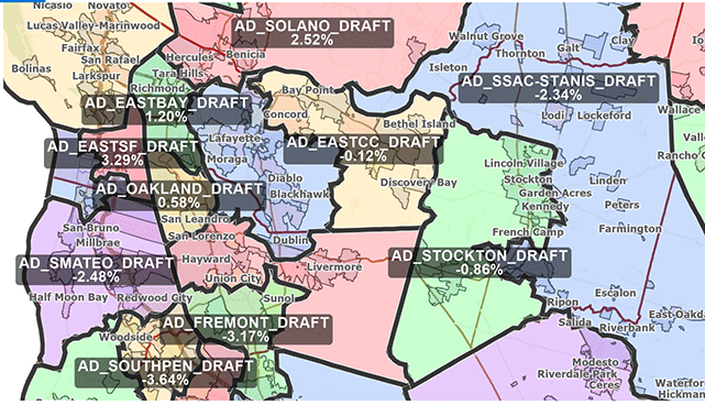
Currently in Assembly District 11, City of Antioch, City of Brentwood, City of Oakley, Town of Discovery Bay are lumped in with City of Vacaville, City of Fairfield and Rio Vista all represented by Assemblyman Jim Frazier.
Under the new map, East Contra Costa is lumped together with Bay Point and City of Concord keeping it a Contra Costa County District—basically, representation would switch to Assemblyman Tim Grayson instead of Frazier who would take over all of Solano County, unless he retires at the end of the year as rumored.
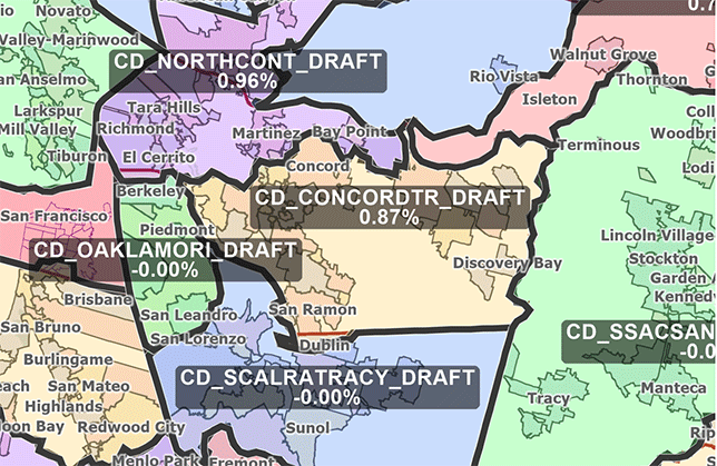
CONGRESS
- 11.10.21 Congressional Draft Map
- 11.10.21 Congressional Shape Files
- 11.10.21 Congressional Equivalency Files
Currently, Congressman Jerry McNerney represents a portion of Antioch, along with the City of Brentwood, City of Oakley, Town of Discovery Bay, Bethel Island and Byron and Knighten. Under the new map, this area would be cut off from the Central Valley.
East County would join Congressman Mark DeSaulnier’s District and for the first time in years keep the City of Antioch from being split in half with joint representation. DeSaulnier’s District would shift away from Richmond and San Pablo and instead pick up East Contra Costa County with a southern border or San Ramon.
BOARD OF EQUALIZATION
- 11.10.21 Board of Equalization Draft Map
- 11.10.21 Board of Equalization Shape Files
- 11.10.21 Board of Equalization Equivalency Files
View draft maps on our interactive map viewer: https://www.wedrawthelinesca.org/map_viewer.
Provide feedback on draft maps here: https://airtable.com/shrQDD2ta2emnSzzO.
2020 California Citizens Redistricting Commission and Statewide Database Release Free Online District Mapping Tools
SACRAMENTO, CA—Today, the 2020 California Citizens Redistricting Commission (Commission) announced the Statewide Database’s release of two free-to-use tools to help Californians submit redistricting plans to the Commission. These are the only redistricting applications through which users can submit their input directly to the state of California’s official redistricting process.
“The Commission is excited to share these free resources to help people draw their own district maps,” stated Commission Chair Sara Sadhwani. “The success of this decennial process depends on the participation of all Californians. We want to hear from everyone and want to know if our line drawing is heading in the right direction.”
“The Statewide Database is proud to provide two map creation tools that are free of charge,” said Karin Mac Donald, Director of the Statewide Database. “The key to participation is access. These online tools aim to expand access to every Californian in hopes that they have the tools necessary to participate in the redistricting process.”
Tell the CRC about your community today!
The previously released Draw My CA Community allows users to draw a map of and respond to a few simple prompts about their Communities of Interest. When finished, users can submit community input directly to the California Citizens Redistricting Commission for consideration in the statewide redistricting process. (https://drawmycacommunity.org/)
Draw My CA Districts is a free-to-use online tool for creating district maps
Through the newly released Draw My CA Districts web application, users can create district maps throughout the state of California and submit those maps directly to the Commission. (https://drawmycadistricts.org/)
Draw My CA is a free-to-use plugin for the open-source GIS platform, QGIS
Today’s release of the Draw My CA QGIS plugin allows users to download a California redistricting application to their own computer. With this plugin, users can create redistricting plans for the state of California and submit those maps directly to the Commission while having access to a full GIS platform. Draw My CA will be available 10/03/2021 at: https://www.redistrictinggroup.org/installer/.
To learn more about these tools, please visit https://drawmycalifornia.org/.
Both the online district mapping tools (Draw My CA Districts and Draw My CA) include functionality to assist users to comply with population deviation, contiguity and assignment checks.
- % Deviation check – tells the user to what extent any of their districts are above or below the ideal population of the distinct type they are working on
- Contiguity check – lets the user know if their districts are contiguous or not
- Assignment check – lets the user know if they have unassigned areas in their redistricting plan
The Commission must follow the following criteria, in this order, when drawing district maps:
- Districts must be of equal population to comply with the US Constitution.
- Districts must comply with the Voting Rights Act to ensure that minorities have an equal opportunity to elect representatives of their choice.
- Districts must be drawn contiguously, so that all parts of the district are connected to each other.
- Districts must minimize the division of cities, counties, neighborhoods and communities of interest to the extent possible.
- Districts should be geographically compact: such that nearby areas of population are not bypassed for a more distant population. This requirement refers to density, not shape. Census blocks cannot be split.
- Where practicable each Senate District should be comprised of two complete and adjacent Assembly Districts, and Board of Equalization districts should be comprised of 10 complete and adjacent State Senate Districts.
In addition, the place of residence of any incumbent or political candidate may not be considered in the creation of a map, and districts may not be drawn for the purpose of favoring or discriminating against an incumbent, political candidate, or political party.
Every 10 years, after the federal government publishes updated census information, California must redraw the boundaries of its electoral districts so that the state’s population is evenly allocated among the new districts.
In 2008, California voters passed the Voters First Act, authorizing the creation of the independent California Citizens Redistricting Commission to draw new State Senate, State Assembly, and State Board of Equalization district lines. In 2010, the Voters First Act for Congress gave the Commission the responsibility of drawing new Congressional districts following every census.
For more information, please visit WeDrawTheLinesCA.org.